Space syntax in transportation system
Space syntax is a theoretical and methodological framework used to analyze and understand the spatial configuration of urban environments. It focuses on how the layout of spaces influences movement, behavior, and social interactions. In transportation systems, space syntax can be applied to optimize the design and functionality of transport hubs, streets, and public squares. Here are some key applications of space syntax in transportation systems:
- Public Transport Hubs: Space syntax can help design efficient and user-friendly public transport hubs by analyzing pedestrian flow and connectivity. This ensures that people can move easily and safely through these areas.
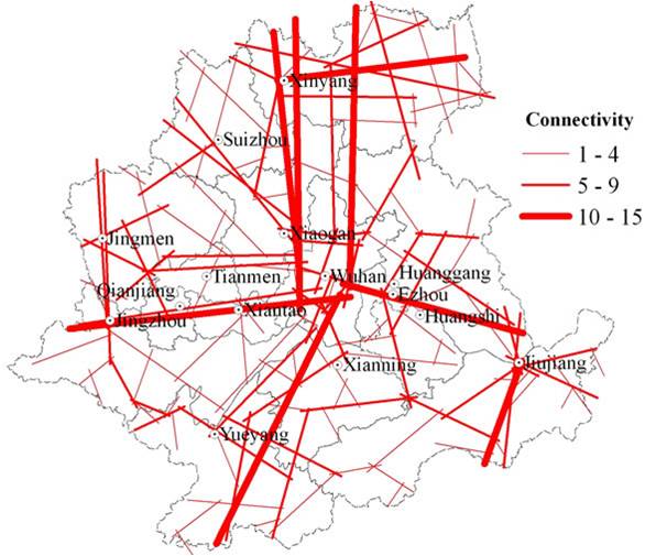
- Street Network Analysis: By examining the connectivity and integration of street networks, space syntax can identify areas that need improvement to enhance accessibility and reduce congestion.
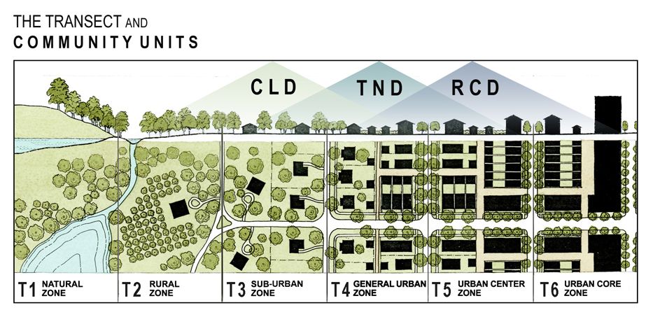
- Urban Planning: Space syntax can be used in urban planning to create more walkable and livable cities by optimizing the spatial layout to encourage pedestrian movement and reduce reliance on cars.
- Safety and Security: Analyzing spatial configurations can help identify potential safety and security issues in transportation systems, allowing for better design and management of public spaces.
- Economic Impact: Space syntax can assess the economic impact of transportation infrastructure by analyzing how spatial configurations affect business activities and property values.
Space syntax in transportation systems has various uses and applications that help in improving urban planning and the efficiency of transportation networks. Here are some key uses and applications:
- Pedestrian Flow Analysis:
- Space syntax can be used to analyze pedestrian movement patterns in urban areas.
- This helps in designing walkable neighborhoods and ensuring efficient pedestrian pathways.
- Traffic Management:
- By analyzing the spatial configuration of road networks, space syntax can help optimize traffic flow.
- This reduces congestion and improves overall traffic efficiency.
- Public Transport Accessibility:
- Space syntax can assess how well public transport hubs are integrated into the urban fabric.
- This ensures that these hubs are easily accessible to a larger number of people.
- Urban Design and Planning:
- Space syntax provides insights into the connectivity and integration of different urban areas.
- This aids urban planners in creating more cohesive and functional urban environments.
- Safety and Crime Prevention:
- By understanding the spatial layout of urban areas, space syntax can identify areas that are prone to crime.
- This information can be used to design safer urban spaces.
- Economic Analysis:
- Space syntax can be used to study the economic impact of urban design.
- This includes analyzing the relationship between spatial configuration and business activities.
These applications help create more livable, efficient, and sustainable urban environments by leveraging spatial analysis to inform design and planning decisions.
Pedestrian Flow Analysis
Overview: Space syntax can be used to analyze and predict pedestrian movement patterns within urban environments. This involves creating a spatial model of the area and using algorithms to assess the connectivity and integration of different spaces. Applications :
- Designing Walkable Neighborhoods:
- By understanding how pedestrians move through an area, urban planners can design more walkable neighborhoods. This includes placing amenities like parks, shops, and public transport stops within easy walking distance.
- Example: The city of London has used space syntax to improve pedestrian routes and enhance walkability in various districts.
- Optimizing Public Spaces:
- Space syntax can help identify which public spaces are underutilized and why. This information can be used to redesign these spaces to encourage more pedestrian activity.
- Example: The redesign of Times Square in New York City used space syntax to create a more pedestrian-friendly environment, resulting in increased foot traffic and economic activity.
- Improving Safety:
- Analyzing pedestrian flow can help identify areas where accidents or conflicts between pedestrians and vehicles are likely to occur. This allows for targeted interventions to improve safety.
- Example: In Seoul, South Korea, space syntax was used to identify and redesign dangerous intersections, leading to a significant reduction in pedestrian accidents.
Tools and Techniques:
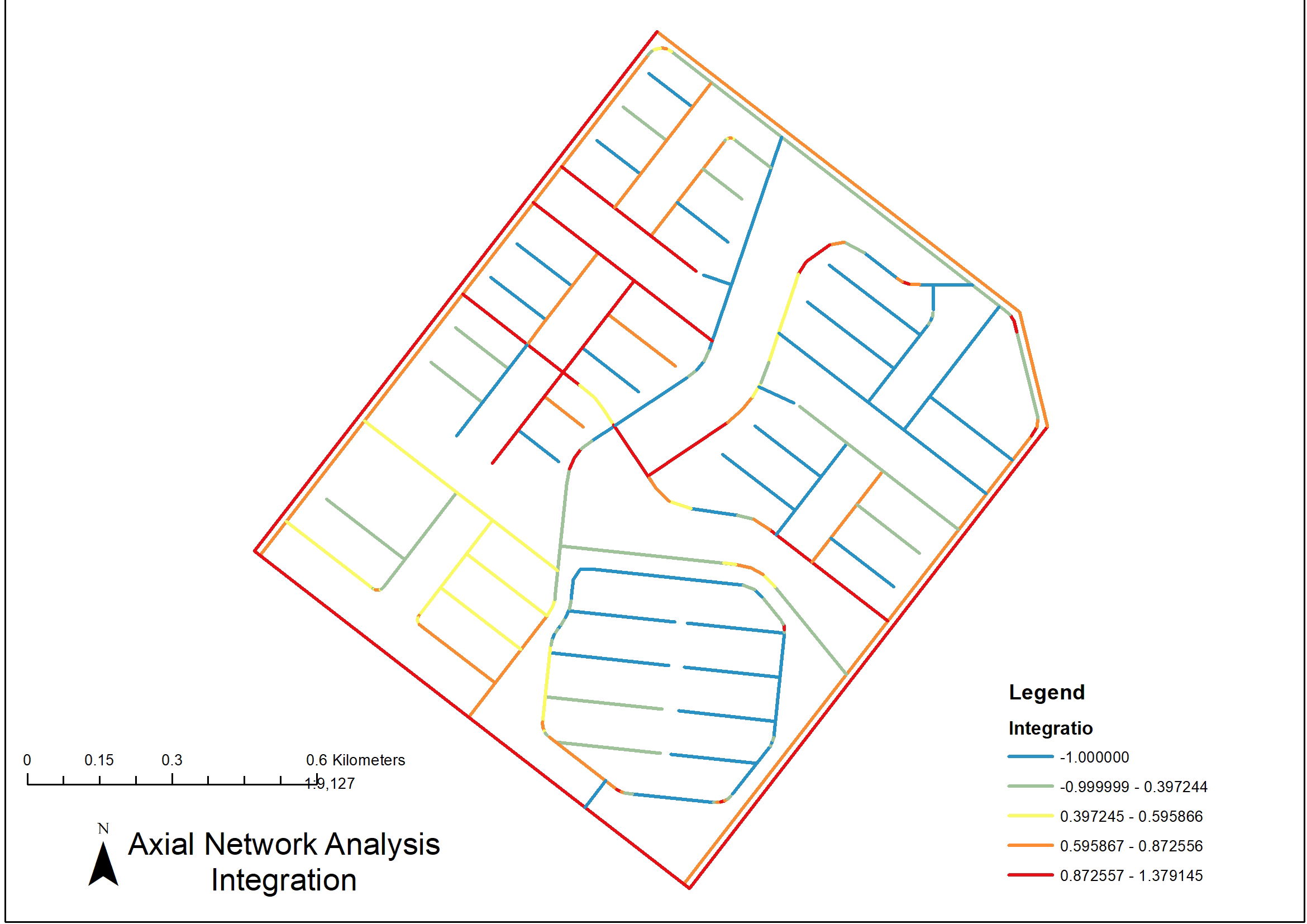
- Axial Maps:
- These maps represent the longest straight lines of sight and movement within an urban area. They help analyze how different spaces are connected and how pedestrians are likely to move through them.
- Visibility Graph Analysis (VGA):
- VGA assesses the visibility and accessibility of different spaces. This helps in understanding how visible and accessible certain areas are to pedestrians, which influences their movement patterns.
- Integration Measures:
- Integration measures indicate how easily a space can be accessed from other areas. High integration values suggest that a space is well-connected and likely to attract more pedestrian traffic.
Example Projects:
- The Walkable London Project:
- This project used space syntax to create a comprehensive pedestrian network plan for London. It focused on improving connectivity and accessibility to make the city more walkable.
- Times Square Pedestrian Plaza:
- Space syntax analysis helped redesign Times Square to prioritize pedestrian movement, creating a safer and more enjoyable environment for visitors.
Benefits:
- Enhanced Urban Experience: By designing spaces that cater to pedestrian movement, cities can create more vibrant and engaging urban environments.
- Economic Growth: Improved walkability can lead to increased foot traffic, benefiting local businesses and boosting the economy.
- Environmental Impact: Encouraging walking reduces reliance on cars, leading to lower emissions and a more sustainable urban environment.
MHC project example
- Rafaha KSA